Latest

Into the Dry River

Thinking back over the past few years, I realized it’s actually been a while since I last went backpacking. I’ve become a lousy peak bagging day hiker who would rather camp next to (or in) his car than in the glorious back country. Overwhelmed by the burning shame of it, I decided it was time to at least spend a night out in the woods.Fortunately I found a willing accomplice in Dave. He’s a med student and is busy a lot of times, but when the opportunity opens up he likes to get outdoors for some fun. This weekend he had to be back by Saturday afternoon, so we hatched a plan to leave Friday afternoon, pack in to a campsite, and then cruise out the next morning.

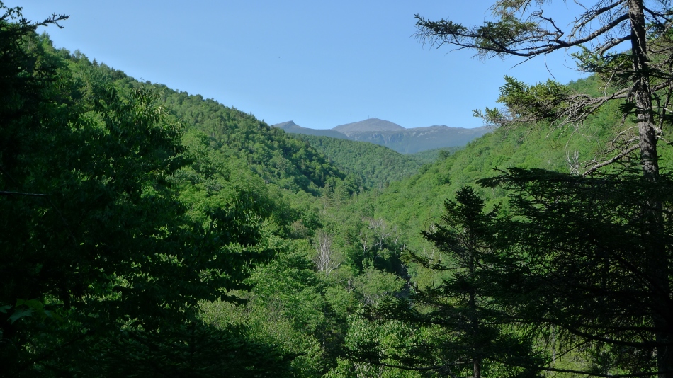
The Dry River forms the broad valley on the south side of the southern Presidential Range. While there are a bunch of trails that offer access to the peaks, the approach is much longer and thus almost all of the traffic to these peaks come from the north side. Consequently the Dry River Trail actually feels like a wilderness trail. The further up the trail you go the less evidence there is of human travel. In some sections on the upper end the moss has actually grown completely over the trail and offers a soft and squishy blanket to walk on.

We started at the Webster Cliff trail and made our way over to the Dry River trail. At first inspection the Dry River valley appears to be a broad and gentle valley that is common here in New Hampshire. However, closer inspection shows that the Dry River cuts a deep ravine into the base of the valley. As the trail attempts to follow along the river, it is often forced to climb up the side of the ravine for a brief while before dropping back down to the river. Nothing too difficult but it does make the trek up the valley more tiring than you might expect.

P1100700

After seven or eight miles of trail we arrived at the Dry River Shelter #3, a rather nice and clean leanto. We had seen only 3 people, the last of which was camped over a mile downstream from us. It’s nice to find that kind of quiet even in the busy White Mountains. We set about gathering some wood to make a fire. I had decided to just skip the cook stove and instead we would chow down on a pound of Polish kielbasa cooked over the fire. This was the first of several mistakes on this trip. As we worked on lighting the fire, my cheap Bic lighter broke apart. We reassembled it only to find that the flint had fallen out and was nowhere to be found. I went to look through my emergency kit and found a couple all weather matches….but no striker. Oops. No fire tonight. So there we were, sitting next to an empty fire ring eating some cheese and crackers and cold kielbasa when Dave looks at our food supply and says we might run out of food. I’m confused because I had packed quite a bit more than I would need. Well, it turns out there had been some poor communication. I had showed up at Dave’s with a box of food with the idea that he could take whatever he wanted for the weekend. I had thought he was going to grab food for himself, he thought I had packed enough for both of us. Oops. Food was going to be a little on the lighter side the next day.

As the light disappeared from the sky we crawled into our sleeping bags for the night. Despite it being a pleasant night for sleeping (it was comfortably cool and entirely bug free) I didn’t do a whole lot of sleeping. I spent the whole night waking up, rolling over, and trying to drift off to sleep again. A bit before 5 AM I rolled over, noticed a little light in the sky, and heard Dave roll over, so we decided to get started on the day. We packed up and continued up the Dry River trail into Oakes Gulf which is formed by the shoulders of Mt Monroe and Boott Spur. This is a rather untouched corner of New Hampshire – even the trail through it is barely there. As we proceeded up the gulf we got a full body workout, ducking under or climbing over blowdown regularly. As the trail climbs above treeline you catch views down the long valley of the Dry River without any man made structures in sight. This section was particularly pleasant; the air was comfortably cool with a soft breeze and we were just climbing up into the gentle warmth of the morning sun. Strolling along the lightly trodden trail meandering through alpine country was the perfect way to spend a morning.

P1100715

Up on the ridge at last, the trail takes you directly to the Lake of the Clouds hut. It’s always a strange feeling to go from the high, lonely alpine country to the bustling business of the huts. We arrived to find the hut packed full of guests eating their breakfast. We braved the noise long enough to refill our water bottles. A hundred yards away from the hut it was back to the quiet of the mountains.

The rest of the day was spent bumping down the Presidential range. This section starts with a few miles of above treeline walking. Then it ducks into the woods but keeps offering up nice views as you trek over Jackson, Webster, and on down the Webster cliff trail. Our early start meant the section from Monroe to Eisenhower was pretty quiet. It’s a fantastic section of alpine trail that tends to get busy on a nice Saturday, but we had it mostly to ourselves. Beyond Eisenhower we started running into bunches and soon hordes of day hikers. Jackson probably had 50 people on it when we got there. It was easily the most terrifying part of the day!

We descended the Webster Cliff trail which follows the top of a nice ridge. The ridge has numerous outcroppings with great views down into Crawford Notch. Unfortunately, we had misjudged our water supply. Back at the Mizpah hut, with about 6 miles of trail left, I had filled a 1 liter bottle which normally would be plenty of water for the distance remaining. However, the day had grown hot and we were exposed to the sun quite a bit so we found ourselves on nearly empty water bottles by the time we hit Webster. Between the limited water and the rationing of food, the last few miles out were less pleasant than they should have been. Morale returned at the trail head though – a woman was handing out treats to thru hikers (and figured we were close enough) so we each got a nice cold Gatorade to finish off the hike!

Despite a few flaws in execution, it really was a great trip. The Dry River Wilderness is an excellent place and the Presidential range is always fun.

P1100721

A Wildlife Extravaganza

So the plan was to climb Fletcher, an easier Centennial 13er.  The trailhead is at the Blue Lakes Reservoir which is at 11,700′ – another high trailhead.  I got there around 5 PM last night and things were pretty quiet.  At least until the wildlife show started.  I walked around and spent a little time watching some marmots play.  Their chubby little faces are always fun to look at (at least when they aren’t eating any of your gear).

A bit later I was hanging out in the back of the car when I looked up and walking right toward me was a group of 3 goats.  They got pretty close:

They proceeded to hang around for over half an hour.  At one point I sat in the back of the car with the hatch open and they literally walked right next to me.  I had to scare them off because I thought one was going to grab something out of the back of the car and run off with it.  The picture below is blurry but you get the idea.

Finally as it was getting dark the goats started to wander off.  Suddenly I turned around, and 5 feet away from my car was a red Fox.  I moved to grab my camera but he got startled and trotted off, so I was only able to get this one blurry picture of him before he was gone.

Not a bad evening.  Once dark had set in I crawled into bed and fell asleep almost immediately, something that rarely happens for me (it usually takes an hour or two before I drift off).  Suddenly, around 11 PM I was startled out of a deep sleep.  I was rather disoriented so it took me a minute to figure out that there was something….some noise……oh…….THAT noise.  Sigh.  I pulled on my shoes, grabbed a headlamp and the bear spray, and jumped out of the car.  I quickly looked around the car and there was no waddling critter to be seen.  So I laid down in front of the car and sure enough – another ugly porcupine.  He was a brave little fella – they usually run off as soon as you open the door.  He had picked the wrong time to be brave.  From a few feet away I gave him a full blast of Grizzly grade pepper spray right in the face.  A few seconds later I heard the coughing and wheezing that let me know I had got him good.  Yes, I am now accustomed to the sound of a wheezing porcupine.  As he ran off I chased him for a bit and tried to hit him again with the spray (just for good measure) but it was pretty windy so I didn’t manage to get him.  With that done, I hoped that was all I would hear from that porcupine for the rest of the night.  I crawled back in to bed.  Around 3 AM I suddenly awoke and thought I heard something.  Once again I hoppped out of the car to look around – but this time found nothing.  A little paranoid perhaps?  I searched in a wide circle around the car just in case something had run off before I had seen it, but things looked clear.  Back to bed.

I woke up just after sunrise and was eating a few lousy Little Debbie’s donuts when I looked over and there was a new trio of goats approaching.  This time it was a momma and two kids.  The two little ones were hilarious to watch – it is the best example of frolicking I have ever seen.  They were bounding around the area and jumping on each other.  Mommy goat was more interested in looking for pee stains.  When I finally got out of the car they seemed a bit more nervous, though they still approached within 15 yards of me.  The mother was acting a little strange.  Every once in a while she would stamp a foot heavily.  Not in the funny way that deer do when they are nervous – more like a “Think what it would do if I stamped on your head like this” kind of way.  I’m not sure if goats are as protective of their young as, say, bears are, but I decided not to stick around and find out.

Let’s see…..oh yeah, I went and climbed a mountain.  It was a really nice hike up a nice basin.  Yatta Yatta….big views….Maroon Bells clearly visible…etc, etc.  When I returned to the car there was one last friendly goat who just wanted to check that I had made it back ok.

Missouri, Iowa, Emerald, Oxford, Belford

With just a few remaining Centennial 13ers in the Sawatch range, I decided to go after Emerald Peak.  I had been avoiding this peak because getting there requires being above treeline for a long time and the weather hadn’t been cooperating.  Now the easiest way to get to Emerald is from the Rockdale trailhead, which requires a good 4WD vehicle to get to.  With my little Outback, I was relegated to the second best option which is the Missouri Gulch trailhead.  This is a popular 14er trailhead, providing access to Missouri, Belford, and Oxford (I just did the Belford/Oxford hike back in June).

Right next to Emerald Peak is Iowa Peak – a named 13er, but it doesn’t have enough prominence to receive an official rank (it only rises 260′ above the saddle with its higher neighbor Missouri).  Nevertheless, I felt obligated to climb it.  Now the easiest way to climb these two peaks from Missouri Gulch is to head over Elkhead Pass (13,200′), travel cross country to the two peaks, and then return over Elkhead Pass.  As it turns out, going over Missouri Mountain and down the ridge to Iowa Peak is only a couple hundred extra feet of elevation while providing a more interesting route and allowing you to brag about bagging another 14er.  So the plan was to go in over Missouri, bag the two 13ers, and return over Elkhead Pass.  Now it just so happens that from 13,200′ at Elkhead Pass you are less than 1000′ below the summit of Belford which is kinda sorta on the way out.  And if you are on Belford, for another 1400′ one can also climb Oxford, which is a little out of the way but it would be kind of embarrassing to climb Belford and not climb Oxford.  And getting those two peaks would let you brag even more.  So with that in the back of my mind, I set my alarm for 4:40 AM and went to bed.

After thinking about it some more, I turned my clock back to 5:30 AM before falling asleep.  I am not a fan of early starts.  Thus, I wasn’t on the trail until 6:00 AM the following morning.  It was just light enough that I didn’t need a headlamp.  My goal for today was to try and pace myself and eat a little better.  Typically I hike at two speeds – on or off.  It is better, however, to keep an easier pace – this will keep you fresher and stronger over the course of a day.  I also lots of times don’t really stop to eat anything (I often get to the summit and have eaten nothing more than a pack of GU and a few peanuts or something like that).  So my goal was to move at a slower pace and eat more consistently early on.

The trail starts with about 1500′ of fairly steep ascent.  I started the morning eating some Frosted Mini-wheats and a pack of GU.  Nothing like some vanilla GU to get your day started.  On the initial ascent I made sure to take it easy – I would even pace myself off some other groups of hikers on the trail.  I usually blow past people in the morning, but I did my best not to pass people too quickly (most people stop and take breaks along the way, which isn’t really my thing, so I ended up passing most everyone on the trail anyways).  Part way up the gulch I started to feel a little bit hungry and stopped immediately to eat a Mojo bar (can you tell I’m proud that I actually stopped to eat food when I was hungry?)  I was soon in the upper basin where I stopped to eat yet another gel.  This was a CLIF gel and it was one of the worst tasting gels I have ever had.  I think I’ll stick to GU from now on.  Another mile and 1500′ took me to the summit of Missouri.  The whole way I had to conciously tell myself to keep my pace easy.

On the summit of Missouri I checked my time – 3 hours 5 minutes for the first 4500′ of elevation, which is actually 5 minutes faster than when I did the same hike last September.  Nevertheless, my legs were feeling very fresh.  The pacing and consistent food intake seemed to be helping.  I chatted with two guys who were doing the Missouri-Belford-Oxford loop.  I figured I couldn’t be shown up by them.  After a 25 minute rest on the summit, making sure to eat and drink, I continued down the ridge toward Iowa.  It didn’t take long to reach this 13, 831′ peak.  I stopped long enough to sign the register and take some pictures and then continued toward Emerald Peak.  This was a beautiful section of ridge.  There’s no trail up there so it is classic Colorado alpine cross country travel.  As I started up Emerald Peak, I spotted two mountain goats up on the ridge, but by the time I got there they had disappeared to somewhere.  Higher up on the ridge I ran into quite a few pika the squeaked and hid under the rocks as I passed.  I spent 10-15 minutes on the top of Emerald Peak enjoying the view.

From Emerald Peak I cut across a section of the Pine Creek basin to get back to the Elkhead Pass trail.  Along the way I stopped at a nice alpine lake and refilled my water.  I was soon back on the trail and cruising up to Elkhead Pass.  Just below the pass I suddenly looked up, and there was my first Colorado sighting of a Bighorn Sheep!  I pulled out my camera to get a picture, then slowly continued toward her taking pictures along the way.  I was surprised that she didn’t run off right away.  Then I realized she was looking behind her and bleeting, so I looked over my shoulder and sure enough, there was baby Bighorn running up over the pass.  I was very excited to finally have seen some Bighorn.

At Elkhead Pass, I was still feeling pretty good, so I started up the trail toward Belford.  As I ascended I knew Oxford was also going to happen.  To get to Oxford from Elkhead pass requires climbing almost to the summit of Belford before descending a ridge and then ascending Oxford.  Then you have to repeat the ridge from Oxford to Belford to get the trail back into Missouri Gulch.  So off I went.  At the summit of Oxford I caught up to the two guys I had spoken with on Missouri.  We chatted for a while and before returning to Belford.  On Belford I met a family who had just reached the summit – 3 generations were represented and they even had a 4 year old who had climbed all the way up the mountain on his own!  Becky and Meg, it’s time to get those kids hiking.

Then it was time for the worst part of the day – the descent to the trailhead.  It’s 4500′ of steep downhill pounding to get out.  By the end my knees were feeling it a bit, but overall it actually went better than I had expected.  This time of year, while the temperature in the high country isn’t too bad, when I’m hiking out in the hot afternoon sun I tend to get a bit overheated.  And an overheated Dunbear is a cranky Dunbear.  Fortunately, there is a stream right next to the Missouri Gulch trailhead, so after getting back to the car I went down and stood in it for a while.  The cold-but-not-too-cold water felt great on my achy feet and dumping a bunch of water on my head helped drop my body temperature.  After that I ate two pieces of leftover pizza and a peanut butter and honey sandwich while drinking 1-2 liters of water to close out a good hike.  I checked the GPS which told me the day had been 16.2 miles with 8000′ of ascent for a 5 peak day.


–PICTURES–